
If you double click some where in the menu above it will expand in size and become more readable.
Enjoy!
I mentioned in an earlier post that there is a small restaurant that seats 24 in the stern of the AmaVenita as shown in the Photo, called the Chef's Table. The chefs aboard take it in turns to design and prepare a taster menu for a week at a time. Although Lesley, Bob and I had eaten here on the first night of the cruise the menu had changed since then and so we decided to enjoy this experience once more.
This time I can show you the full menu. I have found a way of uploading a photo to a post to make it large enough to read. I will, therefore, post the Taster Menu on a separate post.
What I really wanted to share with you is some views of the final two 24.7m deep locks from this restaurant.
The first photo is taken at the Eckersmuehlen Locks looking back over the top of the lower level raised gates at the canal beyond from which we had just risen 25m!
The last two photos are taken at the Hipolstein Locks abut an hour later. Apologies for the reflection but it was getting dark but I think it adds a bit of animation to the photo.
I will close this post and the Blog with a final photo as we cruised away from the Hipolstein Locks.
I hope you have enjoyed reading about my travels as much as I have enjoyed writing about this river cruise.
I leave on the 28th June 2024 to join another Silversea Expedition cruise to Greenland and Canada via the first part of the North West passage ending at Churchill on the Hudson's Bay so I will be inviting you to join me for another Blog! So until then Au Revoir!
The sharp eyed amongst you – and you will have to have been sharp eyed because the font size of the list of locks in the last post came out much smaller than I had anticipated – will have also seen that in addition to the 68 locks there were two aqueducts each 24.7 metres in height. The first over the Schwarzach River and the second over the Finsterbach River. Both aqueducts are on the section of the Main-Danube Canal between the 19.5m Elbach and the first of the 24.7m Eckersmuelen locks.
The photo above was taken as we transited the second aqueduct. See a lorry on the road 24 metres below.
That's all for this posting because the photo file size, even compressed, is about the limit for the Blog.
The cross-section of the Main-Danube canal waterway is normally trapezoidal, with 31 metres (102 ft) width at the bottom, 55 metres (180 ft) width with at the water surface, 4 metres (13 ft) of water depth, and a side grade of 1:3. The largest authorised vessel is 190 metres (620 ft) long and 11.45 metres (37.6 ft) wide. Before you ask all the tourist craft are built to provide about 8-10 inches clearance on either side of the vessel when in the lock! At tight squeeze when entering and all done at some speed!
This link shows the profile of the canal as it rises to its highest point at the European Continental Divide 406 metres above sea level.
https://en.wikipedia.org/wiki/Rhine–Main–Danube_Canal#/media/File:Main-Donau-Kanal-Höhenprofil.svg
I can't find a way of downloading this profile as a photo but suffice to say that the 2 deepest locks at this point are at Eckersmuehlen and Hipolstein each at 24.7 metres height.
To give you an idea of the locks, their location and height I am going to try an experiment and embed in this post a pdf file provided my APT listing the locks. Hooray that has worked!
LOCK LIST AMSTERDAM TO BUDAPEST
2 locks on Amsterdam-Rhine Canal (72 km)
Km Name of Lock Drop or Lift
0.0 Amsterdam, IJ (body of Water 0.5 M below North Sea Level)
59.0 Wijk bij Duurstede Variable
71.0 Tiel Variable
72.0 Entrance to the Waal (Rhine)
No locks on our stretch on the Rhine (Waal) from Tiel in Holland and Germany (415 km)
913.0 Entrance to Amsterdam-Rhine Canal (Tiel)
865.5 Border Germany & Netherlands
857.4 – 865.5 Right Netherlands, Left Germany
686.0 – 690.0 Cologne (37 m)
655 Bonn
592.2 Confluence of the Moselle & Rhine / Koblenz (64 m)
Rhine Gorge with all the Castles
527.3 Rüdesheim am Rhein dock ( 80 m )
496.6 Entrance to the Main (84 m)
34 locks on the Main (386 km)
Km Name of Lock or Town Height in meters
0.0 Entrance to the Rhine
3.2 Kostheim 2.3 m
15.5 Edderheim 3.5 m
28.7 Griesheim 4.5 m
38.5 Offenbach (Frankfurt km 34) 3.1 m
53.2 Muehlheim 3.8 m
63.0 Krotzenburg 2.7 m
77.9 Kleinostheim 6.8 m
92.0 Obernau 4.0 m
101.2 Wallstadt 4.0 m
113.1 Klingenberg 4.0 m
122.4 Heubach 4.0 m
132.3 Freudenberg ( 133 m)
133.0 Freudenberg 4.5 m
147.0 Faulbach 4.5 m
156.7 Wertheim ( 145 m)
160.5 Eichel 4.5 m
174.5 Lengfurt 3.4 m
185.9 Rothenfels 5.2 m
200.6 Steinbach 5.1 m
219.0 Harbach 4.9 m
232.0 Himmelstadt 4.3 m
241.0 Erlabrunn 4.1 m
252.0 Würzburg 2.7 m
251.0 Würzburg ( 172 m)
258.0 Randesacker 3.3 m
269.0 Gossmansdorf 3.4 m
275.0 Marktbreit 3.3 m
283.0 Kitzingen 3.6 m
286.4 Kitzingen (186 m)
295.0 Dettelbach 5.5 m
300.0 Gerlachshausen 6.3 m
316.0 Wipfeld 4.2 m
323.0 Garstadt 4.7 m
332.0 Schweinfurt (202 m) 4.6 m
345.0 Ottendorf 7.6 m
359.0 Knetzgau 4.3 m
367.0 Limbach 5.3 m
381.0 Viereth 6.3 m
386.0 Entrance to Main-Danube-Canal2
16 Locks on the Main – Danube Canal (171 km)
Km Name of Lock or Town Height in meters
0.0 Entrance to Main-Danube-Canal
3.0 Bamberg Harbour (223 m)
10.0 Bamberg 10.5 m
13.2 Strullendorf 7.4 m
26.0 Forchheim 5.3 m
33.0 Hausen 12.0 m
41.0 Erlangen 18.3 m
48.8 Kriegenbrunn 18.3 m
53.7 Aquaduct over Zenn River 2 roads
61.9 Aquaduct over Rednitz River
69.0 Nuremberg 9.4 m
68.0 Nuremberg Harbour (304 m)
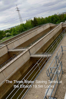
73.0 Eibach 19.5 m
79.0 Aquaduct over Schwarzach River
84.3 Leerstetten 24.7 m
87.1 Aquaduct over Finsterbach River
95.0 Eckersmuehlen 24.7 m
99.0 Hilpoltstein 24.7 m
102.5 European Continental Divide (406 m)
115.5 Bachhausen 17.0 m
122.5 Berching 17.0 m
135.2 Dietfurt 17.0 m
150.7 Riedenburg 8.4 m
166.1 Kelheim (338 m) 8.4 m
16 Locks on the Danube (764 km)
Km Name of Lock or Town Height in meters
2411.0 Entering Danube (338 m)
2397.0 Bad Abbach 5.7 m
2380.0 Regensburg (326 m) 5.2 m
2370.0 Walhalla Monument
2354.0 Geisling 7.3 m
2324.0 Straubing 10.2 m
2230.0 Kachlet 9.8 m
2225.3 Passau (290 m)
2203.5 Jochenstein 10.2 m
2201.7 Border Austria & Germany
2160.0 Aschach 15.4 m
2147.0 Ottensheim 12.1 m
2136.2 Linz (266 m)
2119.5 Abwinden 10.8 m
2094.5 Wallsee 13.3 m
2061.1 Ybbs-Persenbeug 12.0 m
2038.0 Melk 11.0 m
2037.0 Melk (213 m)
2009.0 Dürnstein (209 m)
1980.4 Altenwörth 16.0 m
1943.3 Greifenstein 14.0 m
1933.8 Vienna (151 m)
1921.0 Freudenau 10.0 m
1872.7 Border Slovakia & Austria
1866.0 Bratislava (126 m)
1854.0 Border Hungary & Slovakia
1811.4 Gabcikovo 19.0 m
1853.0 – 1811.4 Gabcikovo Power Plant Canal
1708.2 – 1854.0 Left Hungary, Right Slovakia
1708.2 Confluence with Ipoly or Eipel (Danube Knee)
1652.0 Budapest (96 m) (end of the cruise)
1433.0 Border Croatia & Hungary
I can't finish this Blog without mentioning the amazing civil engineering that enables cargo barges and tourist craft to sail from the Black Sea to the North Sea via the Danube, Rhine-Main Canal, the Main and Rhine rivers. It's really the story of the 68 locks between Amsterdam and Budapest a distance of 1811 km made up as follows:
First of all let me outline the history of the Main Danube Canal. For the full history use the following link: https://en.wikipedia.org/wiki/Rhine–Main–Danube_Canal
The Rhine–Main–Danube Canal is in Bavaria, Germany and connects the Main and the Danube rivers across the European Watershed, it runs from Bamberg via Nuremberg to Kelheim passing over the Franconian Jura. This mountain range is an upland in Franconia, Bavaria, located between the Danube in the south and the Main in the north, its peaks reach elevations of up to 600 metres. The highest point of the canal is 405 metres above sea-level.
The canal connects the North Sea and Atlantic Ocean to the Black Sea, providing a navigable artery between the Rhine Delta, at Rotterdam in the Netherlands and the Danube Delta in south-eastern Romania and south-western Ukraine, or Constanța, through the Danube–Black Sea Canal. The canal was completed in 1992 and is 171 kilometres (106 mi) long.
Early History
There have been several plans and attempts to link the Danube and Rhine basins by canal. In 793, the Emperor Charlemagne ordered the construction of such a canal. King Ludwig I of Bavaria, built between 1836 and 1846 the Ludwig Canal, from Bamberg to Kelheim. This canal had a narrow channel, with many locks, and a shortage of water in the peak section, so the operation of the waterway soon became uneconomic. The canal was finally abandoned in 1950, after a decision not to repair damage caused by bombing during WWII.
Construction of the larger Rhine–Main–Danube Canal, was started in 1921, but not completed until 1992.
By 1962, the Main's channel had been expanded as far upstream as Bamberg and in 1966, after an agreement between Bavaria and the Federal Republic of Germany was reached for financing the completion of the project. The canal was completed and opened on the 25th September 1992.
Route (A map of the route can be seen in the link mentioned above)
From Bamberg to Fürth the canal follows the valley of the Regnitz, a tributary of the Main. From Fürth to beyond Roth it follows the valley of the Rednitz, a tributary of the Regnitz. It crosses the Franconian Jura mountains and joins the river Altmühl near Dietfurt. From Dietfurt to Kelheim on the Danube the canal follows the Altmühl valley.
Commercial History
Although barge traffic regularly plies this river-canal system today it is small in relation to the traffic that had been forecast at the time of its construction mainly due to the growth of the railways and road infrastructure. Today 50% of the traffic is tourist craft. Such craft pay nothing for the use of the locks. The European Union pay for the maintenance, upkeep and operation of the locks. Tourist craft, however, pay for fresh water, power and other services at the mooring points. Electric power is provided from ashore to reduce the use of generators aboard the vessels.
See the next posting for details of the location and depth of each lock.
If anything better demonstrated the vibrance of Budapest then it was my visit this morning to the Great Market Hall just 400 metres further along the western bank of the Danube in Pest. It was a pleasant stroll in bright sunshine along the bank of the Danube. Incidentally did you know that the name 'Blue Danube' derives from the reflection of the blue sky on the waters of the river! It was a clear blue sky so yes; the Danube was blue!!
It turned out to be the hottest day so far, reaching 27 Centigrade by the afternoon!!
The architecture of the market building is impressive. It was built in 1897 and offers a large variety of stalls on three floors. The entrance gate has a neogothic touch. Another distinctive architectural feature is the roof which was restored to have colourful Zsolnay porcelain tiles manufactured in Pécs. The size of the building is 10,000 square metres and is covered by a steel structure resembling that of a Railway Terminus. During World War II the market was significantly damaged and remained in a deteriorating condition until renovation to its original splendour began in 1991. The building re-opened in 1997 and judging by the number of people browsing the market stalls this morning, it continues to be one of the most popular tourist attractions of the city.
Sadly, I don't have any photos to support my impression but this link will take you to a site that shows images of both the inside and outside: https://budapestmarkethall.com/great-market-hall-budapest
I only found 2 floors. The third turned out to be in the basement catering for fishmongers and specialist meat stalls. The hundreds of stalls sell: fruits, vegetables, dairy products, salamis, pickles, fresh fish, Hungarian paprika, Tokaj wines, souvenirs of all kinds, bags, clothes, pans and pots, and even home style meals, or Hungarian snacks at the upper floor food stands and eateries.
Above are a few photos of my own as a memory of this colourful marketplace.
Watch this space for the next couple of posts which will all be about the amazing engineering behind the Main-Danube Canal and the 68 locks through which we we passed on our 1811 km cruise from Amsterdam to Budapest.


